A HISTORY TIMELINE:
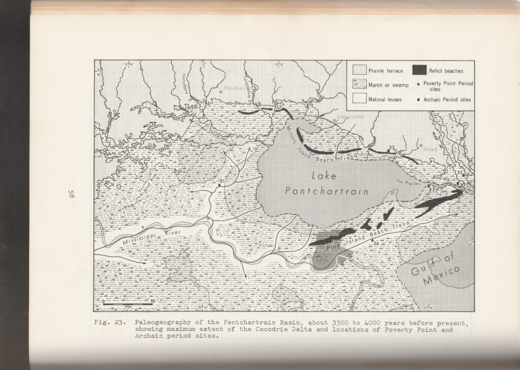
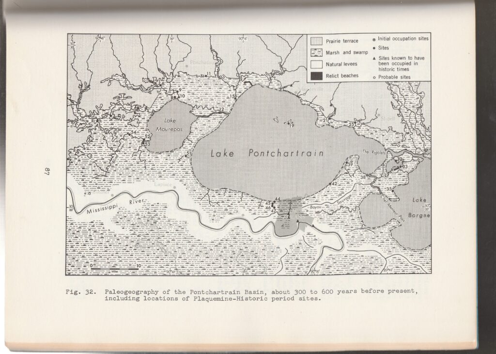
4,000 – 3,500years before present – The underpinnings of the Isthmus of Manchac and a half-size Lake Pontchartrain are created as the Mississippi River’s Cocodrie and St. Bernard deltas builds eastward though the future River Parishes and southeast Louisiana.

2,500 – 2,000years before present – Lake Maurepas begins to form.

800 BC – 1400 – Indians of the archaeological Woodland Period occupy the banks of Bayou Jasmine for 2,200 years (near the site of the future Ruddock and excavations for I-55).

1699 – After Pierre Lemoyne d’Iberville explored the lower Mississippi River to solidify the French king’s claim to the entire river valley, he travels through Pass Manhac back to his ship in Mississippi Sound.

1699 – 1803 – Pass Manchac became an important thoroughfare for colonial exploration and settlement and an international boundary between territories claimed by France, Britain and Spain.

1803 – Pass Manchac is once again an international border after Louisiana is purchase from France and the southern half of the Isthmus of Manchac becomes part of the new and expanding United States. The northern half of the isthmus, formerly in the possession of Great Britain, remains in the hands of Spanish West Florida.

1847-1927- Crevasses at Bonnet Carre, Nita Plantation and elsewhere deliver huge quantities of Mississippi River water and sediments to Lakes Maurepas, southwestern Lake Pontchartrain and the southern end of the Manchac Greenway.

1858-60 – Construction of the New Orleans, Jackson and Great Northern Railroad is completed through the Isthmus of Manchac. This includes a new bridge across Pass Manchac completed at great expense.

1862 – Confederate batteries on the north sides of North Pass and Pass Manchac are taken by Federal troops who establish Fort Stephens on the south bank of the main pass. 

1863 – The Civil War conflict destroys the railroad bridge and lighthouse at Pass Manchac.

1840 –1915 – Communities of Frenier, Ruddock, Galva, Akers, Strader, Wagram, Owl Bayou, Sharkey, Jena and others populate the western shore of Lake Pontchartrain. Some are located at railroad watering stops and with the railroad, farmers can send their produce to city markets.

September 29, 1915 – A hurricane from the West Indies tracked across Grand Isle and Lake Pontchartrain and killed 275 people in Louisiana, a great number of them on the western shore of the lake. The storm had the highest winds and the lowest barometric pressure ever recorded for any hurricane up to that time and today would be rated as a strong Category 4.  The great storm-surge destroyed the small farming communities on the lakeshore and salt water poisoned the land. The Manchac Isthmus eventually healed, however, most of the small communities up and down the isthmus were gone forever.

1927 – Components of the New Orleans West End to Hammond Lakeshore Highway were installed – the Jefferson Parish shore was paved (its a bike path today), bridge pilings were driven across the lake-end of the Bonnet Carre Spillway and the road from Laplace to Ponchatoula on the Isthmus of Manchac was completed.

1934 – Middendorf’s Seafood and Fried Chicken Restaurant was established at Akers.

1960 – U.S. 51 was completed.

September 13, 1974 – The Manchac Bridge Disaster happened when a barge stuck the bridge’s pilings and knocked-down a section of the road’s bridge’s decking as vehicles were crossing. One death was confirmed and others were suspected.

Note the darker paint on the replacement bridge girders.

1979 – With the opening of the Manchac Swamp Bridge, one of the world’s longest over water, Interstate 55 on the Isthmus of Manchac was completed.

2016 – The Manchac Greenway was established by the Louisiana Department of Transportation and Development with the installation of designating signs along the roadway.